Monday, November 18, 2013

Kent Ridge Park , Hort Park

Pasir Panjang Terminal , from Kent Ridge

 It has been a soggy November but this morning offers a rare window of opportunity for a rain-free walk in the park. Seize the day I did and after depositing the little one at Science Hub, it was me-time at the nearby Kent Ridge Park, where Bukit Chandu is.

The park is not exactly accessible by public transport. The nearest bus stop is located at Pasir Panjang Road which demands a very steep climb.

A walk in the ( Kent Ridge ) Park
I parked the car at car park B, steps from Kent Ridge Park’s lookout point. Facing west,  I took in Pasir Panjang Terminal and the western sea,  partially obscured by tree tops. 10.30am is a decent time for a nice , clear photo as the Terminal and sea was lit up by the morning sun.

Trees, trees and more trees at the canopy walk
South of the lookout point, a lush avenue of trees led to the canopy walk and Bkt Chandu. The canopy walk is one of Nparks works that links Kent Ridge to the Southern tip of Singapore, Mount Faber. The walk, a 20m odd boardwalk with lookout points was immaculately maintained, free of slippery leaves and debris.

Decisions, decisions, decisions

Kent Ridge Park

Near Kent Ridge lookout point
The boardwalk ended at the entrance of Bukit Chandu, a heritage point that witnessed fierce fighting between the local freedom fighters and the Japanese in WWII. Bukit Chandu was closed because it  was a Monday but a nearby plaque gave a vivid account of the battle which, as history knows, we lost.

Hort's own Lombard Street
At this point, a short slight of stairs led to a Lombard Street like walk path that opens up to the nursery at Hort Park. Hort Park was stately even at the 11 am sun, with a huge swath of green that housed many greenhouses.  


A little of Botanic Gardens, no ?

I especially recommend the community farm that grows dwarf versions of every possible herbs and vegetables.  There was a small playground which was too hot to enjoy in the noon sun.

Community farm at Hort

Vineyards the Restaurant is located the end of the landscaped garden. At this point, I refreshed myself at the public amenities ( including chilled water cooler ). Hort Park, like Botanic Gardens and the zoo, has one of the nicest, eco-friendly public washrooms in Singapore which I highly recommend.

As seen from Vineyard at Hort Park
Mozaic murals, at Vineyard
The total distance from Kent Ridge Park to Hort Park is about 1.5 km which takes a leisurely 1 hour, more if you are a chronic shutterbug.

Greenhouse at Hort, where testbeds of plants are housed
I backtracked my way uphill from Hort to Kent Ridge. Between the stone steps and canopy walk up to Kent Ridge , I much prefer the scenic canopy walk. Unless I am in a hurry, the steps look murderously unending all the way to the top. Not to forget, there’s not much of a view using the stairs up too.

All in all,  the 3 km walk gives a good summary to the area which is impossible to navigate by car. If these parks have a personality, I would think Hort is stately as Kent Ridge is friendly. Much as Hort is beautifully manicured, I prefer the shadier Kent Ridge. Though the narrow park is flanked by Normantan and Pasir  Panjang, it offers great views and is cooler because of the trees.

Normanton Park, from Kent Rdge
Pasir Panjang at noon

Either end of the walk, there’s not much in the way of drinks, except for a vending machine and water cooler. Bring along a bottle of cold water because the Singapore sun does a good job of sizzling you up at any time.


Friday, October 11, 2013

Waterway Park @ Ponggol – Sept 2013


View Waterway@Ponggol in a larger map


Ponggol shore
It has been wet, wet,wet for many days straight so this outing was one executed in faith.  Our place of interest was Ponggol Waterway Park , Singapore’s northern suburb,  located at the north eastern tip of Singapore.

It was a long way from where we are in the west. Traveling counter to peak hour traffic gave me a sort of sadistic satisfaction as I see cars crawling on the major expressways in the direction to city. Even so, from PIE to TPE via Mandai Road, it still took us a dreary 40 odd minutes which is already considered a modest speed. We were so close to joining the morning madness where SLE  splits into TPE and CTE. Pity the folks who pay almost $7 in their daily commute to town at a crawling pace.

Ponggol jetty
After we got off TPE exit 9, it was all the way north on Ponggol Road ending at OBS near the Ponggol jetty.  I am no stranger to the voice of the forest since home for me is at the city’s fringe near the base of Singapore’s highest ‘peak’ surrounded by nature reserves and parks. But Ponggol Park blows me over, because the space was liberating. Joggers were scarce and what human activities there were was confined to retired uncles with their fishing rods and angling paraphernalia. The biggest difference between the park at Ponggol and that at Bukit Timah was the sound of waves lapping on the narrow shore around Ponggol jetty. What could  I say ? Priceless !

This public place is good enough for wedding photos
At this point of writing, Watertown construction was still underway but in a couple of year’s time, the waterfront will be fronted by highrise condos with million dollar views of  Pasir Gudang and Straits of Johor. What a pity only a privilege bunch will have the best part of the precious seafront.

9.45 am : We parked at an asphalt area where the few visitors who parked had exercised civic consciousness with their neat parking. At our right was a cluster of cute restaurants ( Curry Gardenn and Bacon and Booze ).  But unfortunately, they are not open on Mondays.

We took a short walk to the lookout point facing the Straits. A tiny police post operated out from under the lookout point. At least 2 police officers were on the watch ( for unauthorized entry into Singapore ?). Anyway, the patrol car nearby provided much assurance to park users in the very quiet park.

Egret on the lookout!
Nothing will dislodge the egret perched there for a much needed rest!

Clean beach
Hubs took photos, as usual , while the attention monger in me wanted myself in every picture possible. Nature and open space has a way of working on me and I became especially animated. There is nothing not to give thanks for – the mangrove plants still heavy with dew, the clear sand and clean water despite the port and ship vessels across and kingfishers of the most brilliant turquoise flitting from tree to tree when disturbed by my boisterous excitement.  

Mangrove flower
Lotus pond near the public toilet !
By 10.30 am and not quite noon, it was already sizzling hot though the sky was slightly overcast. Coney Island, now called Pulau Serangoon , still looks forested despite the developments across the waters at Ponggol’s end. I visited the island while it was still called Coney Island with classmates some 3 decades ago. Memories of that gathering is hazy , for all I remembered was good friends and even better food ) but it still gives warm fuzzy memories of days gone by.

Johor across
A couple of speedboats zipped back and forth, overtaking a police sea patrol boat that was barely making waves.  On a red marine buoy, a heron perched precariously on the bobbing device with total disregard for the activities around it.

Waterpark 
Waterpark
We headed down to Waterway Park, a minute’s drive down Ponggol Rd. The park has a manmade lake that is fed by Sungei Serangoon via manmade waterway / canal that snakes past the yet to be built housing estate and light rail station. This is Singapore’s public housing at its best, incorporating flats along the island park connectors, wth water bodies and parks as part of its next generation public housing landscape. For foreigners not in the know, they will find it incredulous that so much expense is put into elevating the standard of living in public housing.

Alone
It was not always this calm. Just a couple of weeks earlier, the ST Run in the Park had thousands of people pounding down the Waterpark, Sungei Serangoon and  the coastal front.  

Manicured path. A shame there should be litter nearby.
We explored the Kelong Bridge, its structure resembling the legs of  floating kelongs that dotted the coast decades ago. On both banks of the Waterway, cycling paths and pedestrian footway form an endless loop round park and estate. It is possible to make a 15 km loop simply by walking on the footpaths hugging coast or river. Nparks did an amazing job planting flowering plants, reeds, mangrove and many others that reflected the former ecosystem of the old Ponggol Kampong/village.  My only grouse was that the fish tail palm and fox tail palm were a little out of place because they did not reflect  Ponggol's earlier landscape.


Waterway at Ponggol. Thousands of flats yet to built.
The walkways though beautiful and wide were too carefully manicured, lacking spontaneity. However , on a scale of 10, I would give the park an 8 for the elaborate bridges that bring joggers from one bank to the other every few hundred meters or so. What’s more, there are public conveniences in the middle of the park that takes its theme from the flora and fauna around it.

The last part of the walk at the WaterPark was an  unexpected little adventure. Unable to bear the noon sun, I terminated the walk along the footpath opposite Ponggol MRT station. For the second time in a month, I ‘scaled’ the large slope leading to road level.   A  lookout point at Ponggol Walk was situated opposite the train station but sadly the view was lacking.


Past Watertown condo ( under construction ), we walked along   Ponggol Central, Ponggol Place and Ponggol Drive past  Ponggol View Primary School.  Beyond that, an even more modern Fo Guang Shan temple matched HDB’s uber modern public housing at Treelodge. Stone caricatures dotted the perimeter of the temple’s elevated compound. Hubs was tall enough to capture the adorable stone monks that were contemplating over chess or fetching water from a stony well.


All too soon, we ended at Ponggol Rd, where our car was parked along the roadside. The walk provided a good balance of scenery – from sea to lake, from coast to tiled footpath and mangrove to palms. It is no Gardens By the Bay but still, I am full of gratitude that such a beautiful place beyond the reach of tourist exists for the common man where he lives.


Tuesday, September 17, 2013

June 2013 - Walking the rail corridor from Bukit Timah hill to Buona Vista


View Bukit Timah trek to Buona Vista - rail corridor in a larger map

After years of negotiation, the Singapore government has finally taken over the more than 25km  strip of land which  links Singapore’s south at Tanjong Pagar Station to Woodlands that was Malaysia’s in a historic land swap.

It has been more than a year since this rail corridor has been stripped of its sleepers.  After the initial excitement where almost everyone has descended on this corridor to walk, take photos and bike, the former railway is finally undergoing a recuperation period. Grass has grown on the parts where   sleepers previously laid and vegetation has encroached into the space where trains used to run. Had it not been for NEA’s maintenance, there would not have been any trace of the former railway tracks.

Starting from Bukit Timah :

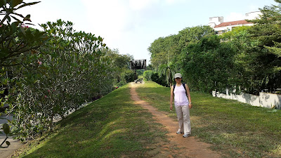
We chose a weekday to check out the rail corridor in order to avoid the bikers  and joggers who were constantly jostling for space with each other.  From home, it was a kilometer walk to our starting point at Bukit Timah Nature Reserve at Hindhede Road. Hubs and I half crawled and climbed up the steep slope that led to the railway behind The Mondrian, clutching on tufts of overgrown grass.

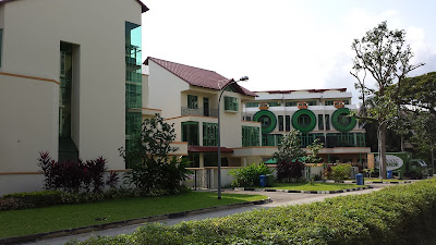
We spied condos at the beginning of our trek. This point provides a chicken out if the going gets tough.
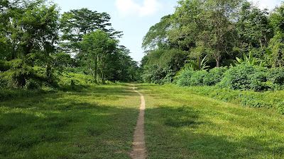
This sandy part was where the railway formerly ran

It was not the best spot to start our trek because there was no obvious trail or clearing leading to the tracks. A better access point would be the other side of the railway bridge but this we only discovered at a second trekking session a week later.

Tall grass obscured the 
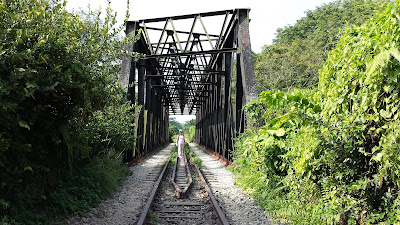
sounds and sights from Bukit Timah Road once we were on the former track.  The black rail bridge is only the width of Hindhede Road below, but it is a poignant reminder that not too long ago, trains chugged along it to Malaysia.

We turned north and walked on the grass where ballast  previously ( granite bed for sleepers ) lie. This makes walking easier without the risk of twisted ankles. Bukit Timah Road flanked our right while the boundary of the nature reserve flanked our left. A couple of monkeys ignored us because  we did not carry plastic bags which they associate with food.

Near Dunearn and Bukit Timah junction. Standing on what was previously sleepers.
We walked on the green corridor that ran under the PIE turnoff from Bukit Timah Road. Graffiti artists had visited and left their indelible, artistic marks on the concrete walls. Tyre sounds boomed above our heads and colorful graffiti on both sides reminded me of some forgotten place in LA.

At Rifle Range Road, the trek opened up to a clearing. It was almost   road level and a pathway provided access to the bus stop on our right. Garden Vista was just before us and it was one section that is closest to ‘human civilization’.

Over Dunearn Road and the canal
The rail bridge over Dunearn Road and Bukit Timah Road was one of the longest on our trek. I like this section because   the enormity of the black truss  gives a feeling of reliability and security. At this juncture, we traipsed carefully over the remaining sleepers, some made of concrete and others of wood. The manufacturer’s imprint on the fasteners connecting the track to the sleepers was still visible.

Okay , we made the first km. Time to celebrate.
Bukit Timah Signalling Station
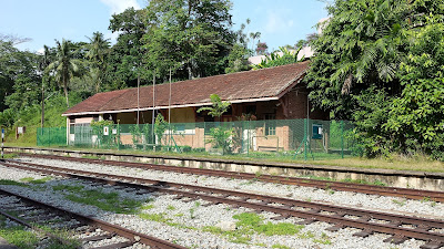
Now a property of SLA 
This sign must have meant a lot to different people over the past 
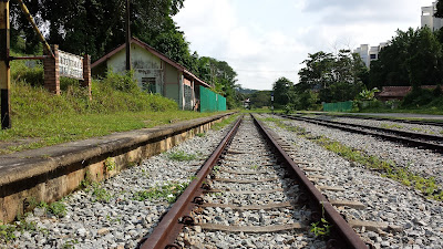
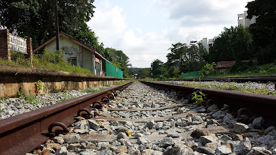
Sections of rails at the signaling stations are called blocks.
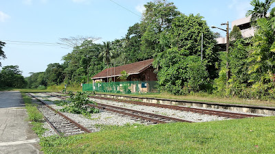
At the other end of the bridge stood the defunct Bukit Timah signalling station. This section forms the broadest part of the corridor, apart from the terminal at Tanjong Pagar. The sounds of the city ebbed and cries of birds took over time and space.

You won't believe it is meters away from Clementi Road.
We could see parts of King Albert Lodge and The Sterling at our right and left but what caught our attention was this ostensibly huge bungalow overlooking the rail blocks and the unused signalling house .  There were many fruiting banana trees in the clearing that got me planning my next visit so that  I can harvest the fruit.
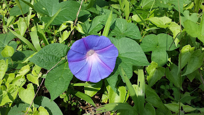
Morning! Glory!
Beyond this clearing, the landscape resumed to a narrow corridor of grass now growing over the former ballast. A  patch of blue and purple morning glory carpeted the floor, attracting butterflies and sunbirds. The last time I saw so many morning glory was many decades ago on the fence of my primary school.

Immediately beyond Bukit Timah Signalling Station, off SIM
Take a break! Phew!
A lady walking her Labrador passed us by, followed by a jogger at the stretch near SIM at Clementi Road. Being close to nature do wonders to people and we greeted each other cheerfully.

I was particular thrilled to walk over the Pandan Canal. For years, I would peer at the windy canal from Clementi Road, wondering where it led beyond. This day I had my curiosity satisfied.

Every section actually looks different, contrary to what it seems here.
At the section of the trek near Clementi and Pandan Road, things got a little muddy. Rivulets of water near the undergrowth streamed here and there, making walking even on a sunny day a messy affair. We were lucky no cross country bikers were around this 5 m stretch to fight for space with us or we would end up in a muddy mess.

There! I always wanted to snoop the 'jungle' behind Clementi Road. Now I get my wish.
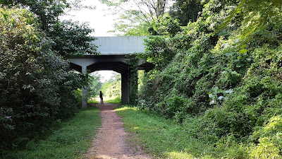
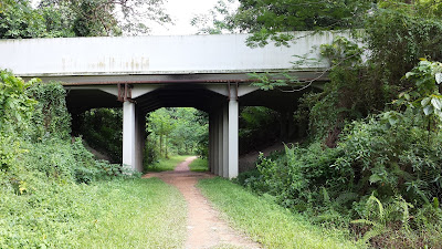
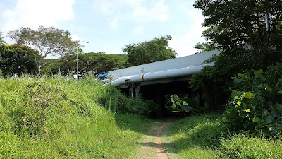
The trek led us under a service road that serves Holland Road. It was not a pretty section because  the space was only enough for the train. Vehicular sounds became more pronounced as we walked towards Holland Road above us. At Holland Green, a jogging path ran parallel to the trek for a couple of meters before parting ways.
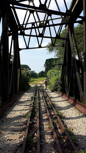
Black Truss 
Near Pandan Canal, off Clementi Rd
Holland Rd above. We just navigated over the muddiest stretch of the walk.
The space that could accommodate a train
After the next underpass, we heard the school bells of Henry Park Primary School at our right. Caltex Station was at our left but all I could think of was Cold Storage behind the petrol kiosk where a cold drink or popsicle would be so possible. We were still below road level and the steep slopes pregnant with bushes made going up impossible. Now at 11 am, I was drying up inside and out. It made admiring the green corridor difficult.

We oohed and aahed at the back of huge houses with lush gardens. Some pockets of backyards were surreptitiously cordoned off as extended personal gardens in the days of the Malaysian rail. Hmm, I wonder what the Land Tax folks think.

Nearing the main thoroughfare at Holland Road.
At Bouna Vista Road, I decided to call an end to our walk. The last few hundred meters after Henry Park Primary School was flanked by high fence ( Ulu Pandan Community Center on our right and houses on our left ). I felt claustrophobic and hemmed in especially when the track is mostly below road level even though we were out in the sun and the high fences on both sides did not help either. Bouna Vista provided the first break and with hub’s help, I overcame the slope and a drain to  find myself in the middle of Bouna Vista Road facing the Civil Service College.

By then it was almost high noon. We made our way to The Star where we rewarded ourselves with a long cool drink and a pig-out at the hawker center.

In the 2 hours, we covered a modest distance of about 6 km. It was an undulated walk and other than the muddy section near Holland Park, was simply a walk in the park.